Geography of North Africa and the Middle East
http://education.nationalgeographic.com/education/mapping/interactive-map/?ar_a=1
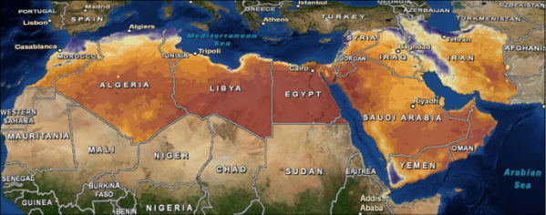
North Africa and the Middle East includes the countries of Morocco, Algeria, Tunis, Libia, Egypt, Israel, Lebanon, Cyprus, Syria, Turkey, Iraq, Jordan, Saudi Arabia, Yemen, Oman, Kuwait, and Iran.
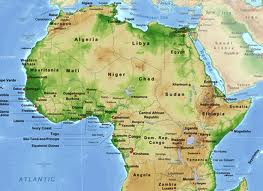
Geographical Features in North Africa and the Middle East:
Nile River- The longest river in the world, traveling north from east Africa to the Mediterranean Sea. It is 4150 miles long.
Delta- The delta formed in northern Egypt where the Nile River fans out. It is very fertile and useful for farming.
Atlas Mountain- A range in North Africa spreading from Morocco to Tunisia
Mediterranean Sea- Large body of salt water lining many coasts of countries. Used for trading and transportation.
Sahara Desert- This desert covers one tenth of the land in Africa and holds the world's highest temperature ever recorded, 136 degrees f in 1922.
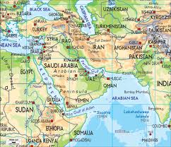
"The Empty Quarter"- Name given to a region in the Middle East, mainly in Saudi Arabia were the land is hot and arid.
Tigris River- A river in the Middle East that borders the Fertile Crescent.
Euphrates- The second river in the Fertile Crescent. Causes a large area useful for faming.
Jordan River- A river running through Palestine and Jordan, it empties out to The Dead Sea.
Suez Canal- Built in 1859-1869, it is a man made canal that connects the Mediterranean Sea and the Red Sea.
Red Sea- Land locked sea separating Africa and the Arabic Peninsula.
Black Sea- Sea surrounded by Ukraine, Russia, Georgia, Turkey, Bulgaria, and Romania. It connects to the Mediterranean Sea. Used to connect countries to trading routes in the Mediterranean Sea.
Caspian Sea- The largest land locked body of water surrounded by Russia, Kazakhstan, Turkmenistan, Azerbaijan, and Iran.
Persian Gulf- Part of the Arabian sea. It is connected to the Strait of Hormuz and the Gulf of Oman.
Strait of Hormuz- Important strait that connects to the Gulf of Oman and the Arabian Sea.
Zagros Mountains- Mountain range in western Iran.
Geographical Features in North Africa and the Middle East:
Nile River- The longest river in the world, traveling north from east Africa to the Mediterranean Sea. It is 4150 miles long.
Delta- The delta formed in northern Egypt where the Nile River fans out. It is very fertile and useful for farming.
Atlas Mountain- A range in North Africa spreading from Morocco to Tunisia
Mediterranean Sea- Large body of salt water lining many coasts of countries. Used for trading and transportation.
Sahara Desert- This desert covers one tenth of the land in Africa and holds the world's highest temperature ever recorded, 136 degrees f in 1922.
"The Empty Quarter"- Name given to a region in the Middle East, mainly in Saudi Arabia were the land is hot and arid.
Tigris River- A river in the Middle East that borders the Fertile Crescent.
Euphrates- The second river in the Fertile Crescent. Causes a large area useful for faming.
Jordan River- A river running through Palestine and Jordan, it empties out to The Dead Sea.
Suez Canal- Built in 1859-1869, it is a man made canal that connects the Mediterranean Sea and the Red Sea.
Red Sea- Land locked sea separating Africa and the Arabic Peninsula.
Black Sea- Sea surrounded by Ukraine, Russia, Georgia, Turkey, Bulgaria, and Romania. It connects to the Mediterranean Sea. Used to connect countries to trading routes in the Mediterranean Sea.
Caspian Sea- The largest land locked body of water surrounded by Russia, Kazakhstan, Turkmenistan, Azerbaijan, and Iran.
Persian Gulf- Part of the Arabian sea. It is connected to the Strait of Hormuz and the Gulf of Oman.
Strait of Hormuz- Important strait that connects to the Gulf of Oman and the Arabian Sea.
Zagros Mountains- Mountain range in western Iran.